Assessment of Plastic on Goode Beach May 2020
Community assessment of plastic on Goode Beach and its wildlife – Dr. Harriet Paterson and the Goode Beach community
Funded by State NRM Community Stewardship Grants 2018 – Small – CSGS18556
The Heritage Trail
The Proposed Heritage Trail
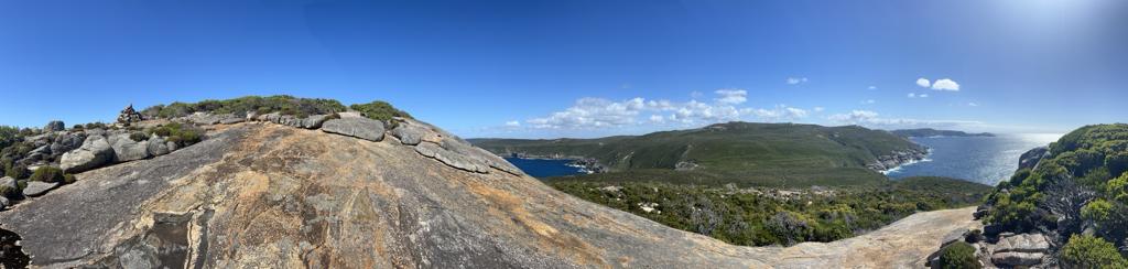
The Frenchman Bay Association has developed a detailed plan for a circular heritage trail to run along the top of the escarpment at Whalers Beach, down a flight of stairs and on to the beach. The trail extends along the beach to meet another flight of stairs that would lead walkers to the top. Altogether the walk should take about 30 minutes for those who want a brisk walk and for those who want to study the interpretive signs or take in the scenery it may take a bit longer.
Why do we need this trail?
Visitors would be able to enjoy not only in the panoramic scenery but also the rich and largely unknown history of the location.
There are no signs to indicate the existence of the Vancouver Dam, the Norwegian Whaling Station, or wrecks that are visible from the shore. Nor is there any awareness that two centuries ago vessels from Britain, France, the United States, Norway and other European countries anchored here under the watchful eyes of Noongar men and women. What brought them to Whalers Beach were the safe anchorage and the fresh water springs that flowed onto the beach, even at the height of summer. For some years sailing and steam ships drew their water from the springs and in Albany’s early years residents themselves were dependent on these springs for the town water supply. There are many stories to be told about the fresh water springs and the people who were drawn to them. These can be found elsewhere on our website.
The signage we have in mind would describe:
- stories of the use of this place by the Noongar people and their early contact with Europeans;
- the critical importance of the fresh water springs to the seafarers Vancouver, Flinders, Baudin and the others who followed;
- the Vancouver Dam and jetty that were so important to the development of Albany;
- the quarantine camp on Mistaken Island;
- the Norwegian Whaling Station of which so little remains;
- the wrecks on the beach;
- the hostel popular with honeymooners in the 1940s;
- the history of the islands- some is colourful and some dark – seen from the escarpment; and
- the work of the early botanists, the visit of Charles Darwin and other scientists.
This location should become a major tourist destination. There are few sites along the Australian coast that have so much history concentrated into such a small geographical area. However, the rich history of this area is not well publicised and is in danger of being lost. We believe that there is the potential make this place a major destination for visitors from around Australia and overseas when they visit Albany.
Where are we up to? In 2014 the Frenchman Bay Association received a grant from Lotterywest which enabled us to engage H + H Architects to undertake a feasibility assessment for us. We also consulted widely with stakeholders. The feasibility study was completed in 2015 and the recommendations of the environmental consultants were taken into account. Quantity surveyors estimated the cost of the construction. We are now waiting for approvals from the key stakeholders to begin to approach potential funding bodies.
If we are successful this will be our second project in this area of Goode Beach. In 2002 the Frenchman Bay Association joined the City of Albany and the Water Department in constructing the trail leading from the Lookout on Vancouver Road that presently provides a panoramic view of Frenchman Bay.
If you like the idea of the Heritage Trail, send us an email!
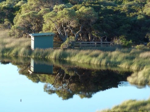
The Lake Vancouver Bird Hide
The Lake Vancouver Wetlands
Lake Vancouver is a small fresh water lake and wetland within a City of Albany Nature Reserve, located on the Vancouver Peninsula, about 200 m west of Goode Beach on Frenchman Bay. Because of its pristine condition and unique position so close to the ocean, the Lake Vancouver wetland is listed in the South Coast Significant Wetlands Database and is currently being used as a case study to help determine wetland buffer zone guidelines for Western Australia.
From 2005 to 2007, the Department of Water completed monitoring (physical, chemical and biological) of the Lake Vancouver wetland, as part of the South Coast Wetland Monitoring Program and from these studies concluded in 2008: “The main consideration for Lake Vancouver is to maintain the integrity and protection of this relatively pristine coastal system.”
The wetland is currently in remarkably good condition because of the surrounding buffer zone of thick, natural vegetation and the lake connection to shallow, fresh groundwater. Lake water quality is good (but not classified as potable) and the nutrient content (phosphorous and nitrogen) of the water is relatively low.
Water levels in the Lake Vancouver wetland vary seasonally and depend on rainfall, surface runoff, and groundwater levels. The infiltration of rainfall and surface runoff into the ground has formed a shallow lens of fresh groundwater, which supports the biota of the wetland and floats on denser, saline groundwater at depth (see cross-section). During the summer (high evaporation and little rainfall), lake levels decline, but are maintained by groundwater inflows from the shallow lens. During winter, rainfall and runoff raise lake levels and recharge the fresh groundwater lens.
Any future residential development around Lake Vancouver needs to be limited, because this fresh water wetland system is very fragile and needs careful management. Any significant reduction in the size of the fresh groundwater lens (for example, by pumping groundwater near the lake or by pumping water from the lake) could result in salinisation of the wetland by the upward movement of the underlying saline groundwater.
Until 2012, public access to any part of the lake and wetland was very limited due to the thick fringing vegetation and swampy, waterlogged conditions during the winter. In many ways, this maintained the pristine character of the wetlands.

Building the Bird Hide
In order to provide public access to Lake Vancouver, not only for bird watchers but also for the public, the Frenchman bay Association sought to get the approvals from key stakeholders to construct a bird hide. It was critically important that the hide had a minimal environmental impact on the lake and its surrounding vegetation and advice was sought from City of Albany officers, the Department of Water, and from the Noongar community. The path providing access was carefully chosen, and all steps were taken to make sure that the the vegetation and the water quality were preserved. For example, the stumps on which the bird hide rests are made of jarrah timbers and not the cheaper, treated pine. The Greenskills team lavished a great deal of attention to all the details.
The funding of the construction was made possible by a Natural Resource Management grant; City of Albany funding; significant assistance from City of Albany Reserve Officers; and volunteer labour from the FBA.

Because Lake Vancouver is fresh water it is not filled with algae and does not support a large population of water birds, though various species fly in from time to time. The ‘signature’ inhabitants are Musk Ducks and their courting rituals are a joy to observe in Spring. The plaintive call of the male Musk Duck can be heard for much of the year by residents. The bird hide is also a contemplative place to be and at dawn or dusk the light and shadows show off Lake Vancouver to those who are able to watch from the bird hide.
The bird hide is accessible from La Perouse Road in Goode Beach, by following the directional signage at the intersection of Vancouver and Frenchman Bay Roads and along La Perouse Road
